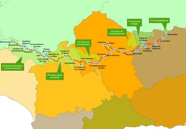
The route of the Sierra Morena trail - GR 48 starts in the village of Barrancos in Portugal and runs along public roads through the province of Huelva, Seville, Córdoba and Jaén along 590 km in 28 stages and an alternative route.
It is designed to take you through six nature parks in Andalucía, coinciding with green footpaths that inter-communicate protected areas, historic and traditional pathways. Landscapes where Mediterranean forest predominates in its purest form along side meadows, declared by the UNESCO to be a Reserve of the Biosphere, with some olive groves scattered about. Territory that is still the habitat for species as scarce as the Iberian lynx, the wolf, black vulture and the Spanish imperial eagle. Villages with history where man has known how to preserve natural values by integrating them into his own way of life. General information Type of path: Lineal with a alternative circular route
Condition and state of the footpath: Approved and signposted in 2010
Total length: 571 km.
Stages: 28 + Alternative GR 48.1
Accessibility: Suitable on foot, horseback and, except for a few isolated stretches, on mountain bike.
Map information: I.G.N./S.G.E. 1:50.000. Huelva: nº 895 Encinasola, 896 Higuera la Real, 918 Santa Olalla de Cala, 919 Almadén de la Plata. Sevilla: 1:25.000 del I.G.N.: 919-I; 919-III; 919-IV; 940-II; 919-IV; 920-III; 920-I; 920-II; 920-IV; 921-III; 942-I. Córdoba: nº 942 Palma del Río, 943 Posadas, 922 Sta. Mª de Trassierra, 923 Córdoba, 902 Adamuz, and 903 Montoro. Jaén: Nº 903, Nº 884, nº 862. The GR 48 “Sierra Morena trail” This impressive itinerary goes through the Sierra Morena mountains in the provinces of Huelva, Seville, Córdoba and Jaén along 571 kilometres and is divided into 28 stages and an alternative circular route. On foot, bike or horseback this long distance, or GR route, is one of the most attractive in the South of Spain. On route you will discover ancient pathways and come in direct contact with the culture and nature of the Sierra Morena. The trail is completely signposted and it has four topographical guides, one for each province, both in Spanish and in English, which can be downloaded for free on the web:
www.senderogr48.com/. It goes through 35 Andalusian municipalities, travellers can enjoy a mixture of landscapes from meadows, ravines, rivers and streams, olive groves, pine groves and Mediterranean scrub. For further information If you need more detailed information on the GR 48 Trail through Sierra Morena you can contact ADIT Sierra Morena E-mail:
gr48@sierramorena.com
There is a very complete website dedicated exclusively to the Sierra Morena trail, http://www.senderogr48.com, where each stage is described, you can download the tracks for GPS navigation and the 4 existing topological guides for each one free and in both Spanish and English.
In addition to the website, Sierra Morena is on facebook: http://www.facebook.com/ADITsierramorena with information for all those who use the trail on its present condition and about Sierra Morena in general, like walking activities or any incident on route. The topographical guides The topographical guides are the ideal complement for a pleasant excursion along any part of the GR-48. They include texts, photos, diagrams, as well as maps and all the necessary material for you to do the route safely. In addition there is a general introduction to each province the trail goes through, there is also information on each place the trail goes through. The stages of the GR-48 The different stages have been designed for you to do on mountain bike, on foot or on horseback covering different distances according to difficulty and planned mainly so that the beginning and end of each stage coincide with towns and villages or places where you can stay and at least get a meal. 01. Barrancos – Encinasola
02. Encinasola – Cumbres de San Bartolomé
03. Cumbres de San Bartolomé – Cumbres Mayores
04. Cumbres Mayores – Hinojales
05. Hinojales – Arroyomolinos de León
06. Arroyomolinos de León – Cala
07. Cala – Santa Olalla del Cala
08. Santa Olalla del Cala – El Real de la Jara
09- El Real de la Jara – Almadén de la Plata
10. Almadén de la Plata – Cazalla de la Sierra
11. Cazalla de la Sierra – Constantina
12. Constantina – La Puebla de los Infantes
13. Puebla de los Infantes – Hornachuelos
14. Hornachuelos – Posadas
15. Posadas – Almodóvar del Río
16. Almodóvar del Río – Sta Mº de Trassierra
17. Sta Mº de Trassierra – Cerro Muriano
18. Cerro Muriano – Villaharta
19. Villaharta – Obejo
20. Obejo – Presa del Guadalmellato
21. Presa del Guadalmellato – Adamuz
22. Adamuz – Montoro
23. Montoro – Marmolejo
24. Marmolejo – Santuario de la Virgen de la Cabeza
25. Santuario de la Virgen de la Cabeza – Viñas de Peñallana
26. Viñas de Peñallana – Baños de la Encina
27. Baños de la Encina – La Carolina
28. La Carolina – Santa Elena
Variante circular GR-48.1: Rivera del Huéznar – Cerro del Hierro
| 
